| PETERVANHAM.COM BIOGRAPHIES BOOKS MUSIC / FILM PUBLICATIONS & LECTURES NORTHEAST INDIA WESTERN HIMALAYAS PHOTO-ARCHIVES UPCOMING CONTACT |
||||||
L A H A U L
Lahaul is situated between the Pir Panjal range and the Great Himalayan chain. The small region actually comprises merely two canyon-like valleys, those of Chandra (Moon) and Bhaga (Sun). In the heart of Lahaul the two rivers of the same name flowing through the valleys unite at a place called Tandi, forming Chandrabhaga, the ”Moon-Sun-river”. Both rivers have their fountain at the Baralacha pass (4883 metres).
The valleys of Lahaul all are elevated app. 3000 metres above sealevel. The summer only lasts from June to early September. Already in October the snow masses close Rohtang pass and Lahaul remains inaccessible until the snowmelt in June. If there weren‘t all the many glaciers in Lahaul, this land like its neighbours would be completely dry and arid. But this circumstance made human habitation possible.
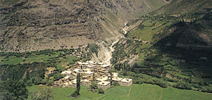
The main part of Lahaul is dominated by the towns of Keylong, the administrative headquarters, and Khardang with its beautiful Buddhist monastery. Following the narrow road along the Chandrabhaga stream towards the west one reaches the district of Udaipur, where the ancient Mirkula Devi temple is located. Towards the north the villages of Tayul, Jispa, Gemur, Darcha and Patseo dot the track along the road through more and more arid terrain towards the Baralacha pass (”pass, where the roads cross”). Beyond the Baralacha-pass the virtually endless plains of Rupshu / Changthang commence.
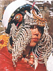
There are three main languages spoken in six dialects in this tiny region. Hinduism and Buddhism both are spread, the West being almost entirely Hindu, the East being almost entirely Buddhist. Summarizingly the main part of the people of Lahaul as they are now may be called a typical Indo-Mongoloid people, showing both Tibetan and Indian influences in their features.
But also other distinct races, clearly differing from the Tibetans, make up the cultural and racial melting pot of Lahaul. The most interesting of them are the semi-nomadic Gaddi people. They migrate between the Kulu Valley, Lahaul and the upper reaches of the Central Himalayan chain in the vicinity of Kunzum pass and the ranges separating Lahaul from Ladakh.
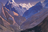
Roerich was an esoteric who was convinced that the mystic country of Shambala would be located somewhere between the Himalayas, Tibet and Mongolia.
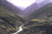
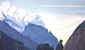
In 1987, when Peter van Ham first came to Lahaul, he made a photograph of the Chenab valley without knowing about Roerich´s work, which shows a view quite similar to that of "Mount M., Lahaul"
Other paintings by Nicholas Roerich furnished in Lahaul or Kulu
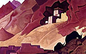
"Khoksar"
"Lahul"
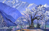
"Krishna - Spring in Kulu"
• Kardang Monastery and town
• Tayul Monastery
• The road from Kunzum Pass to Keylong
• The ascent to Baralacha Pass
• The landscape...
All these highlights and more are the subject of three books by Peter van Ham:
BUDDHA´S MOUNTAIN DESERT
The Secret Tibetan Heritage in the Himalayas
THE FORGOTTEN GODS OF TIBET
Early Buddhist Art in the Western Himalayas
ON THE PATHS OF THE BUDDHA
2000 kms through the Western Himalayas (in German language)
on the Western Himalayas:
KINNAUR, SPITI, TABO MONASTERY,
CHANGTHANG, NUBRA